
Flood Mapping Using Machine Learning at NeurIPS 2025
Date: December 07, 2025
Venue: Climate Change AI workshop at NeurIPS 2025, San Diego Convention Center, San Diego, CA
My participation in NeurIPS 2025 at the Climate Change AI's
Tackling Climate Change with Machine Learning tutorial track
is part of my ongoing research on floods, which is supported by NASA
through their FINESST program. At CCAI's workshop, I focus on practical
approaches for mapping floods using optical and microwave satellite datasets.
I demonstrate traditiona ways to map floods using satellite datasets, the
problems associated with them and how using machine learning partly overcomes
those challenges. You can find more about my session and the CCAI's workshop
here:
https://www.climatechange.ai/papers/neurips2025/120
I actively work on flood mapping using satellite data and have developed both browser-based tools and Python packages for this purpose. If you are interested in mapping floods using Sentinel-1 SAR data without dealing with the complexities of microwave remote sensing or low-level programming, my browser-based application, Global Flood Mapper, may be useful. For automated flood mapping across time and space using Sentinel-1 SAR, my Python package AutoFloods is designed to support scalable workflows. The package is in its final development stage and will be publicly released soon.
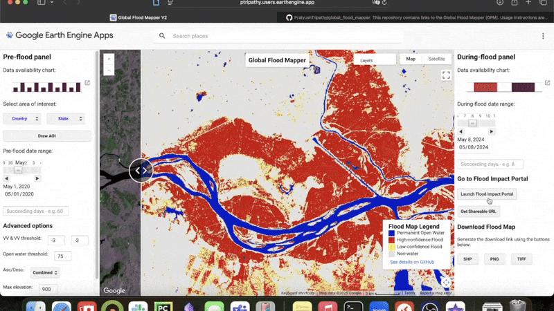
Global Flood Mapper (GFM)
GFM is an end-to-end framework for global flood extent mapping using satellite observations. The following GIF shows the user interface of the GFM:

The published version of the GFM focuses on automated processing of Sentinel-1 SAR data to generate consistent flood extent maps across diverse geographic regions and flood events. You can read details in our peer-reviewed journal article here.
Global Flood Mapper v2 extends the original framework beyond flood extent mapping to support impact-oriented analysis. In addition to delineating flooded areas, it enables population exposure assessment using gridded population datasets, flood depth estimation based on elevation-driven modeling, and the generation of event- and region-level impact summaries. These capabilities are implemented within scalable, cloud-based workflows designed for rapid and large-scale deployment.
Code, documentation, and examples for Global Flood Mapper and Global Flood Mapper v2 are available on GitHub:
https://github.com/PratyushTripathy/global_flood_mapper
My doctoral research
As part of my doctoral work, I am looking at flood events around the world and investigating the uncertainties in existing global flood products. I am particularly interested in this issue because I am investigating the causal relationship between floods and poverty and high quality flood extent dataset is critical to that.
Find my work relevant? Contact me!
If you work on flood mapping or related areas, please feel free to reach out. I am always interested in collaborating with researchers who share overlapping research interests.